
Weather Signs That Predict Storms in Nature: Nature’s Hidden Alerts You Can’t Ignore
Key weather signs that predict storms in nature include towering cumulonimbus clouds that build vertically in the sky, sudden gusty winds shifting direction, a rapid drop in barometric pressure felt through joint aches or animal restlessness, birds flying low or seeking shelter, ants fortifying their mounds higher than usual, leaves flipping upside down on trees like maples, a ring or halo around the moon or sun, and stronger earthy smells from rising humidity.
Introduction
Out in the wild or even in your backyard, nature has its own way of tipping you off about incoming bad weather. Long before radar apps ping your phone, subtle shifts in the environment can signal a storm is brewing. These signs aren’t just old folklore—they stem from real changes in atmospheric conditions like pressure, humidity, and wind patterns. Understanding them can give you a head start on safety, whether you’re hiking, farming, or just planning your day. We’ll break down the most reliable indicators, backed by observations from experts and outdoor enthusiasts, and explain the logic behind each one so you can spot them yourself.
Atmospheric Changes: The First Whispers of a Storm
Storms don’t appear out of nowhere; they build from shifts in the air around us. One of the earliest clues is a drop in barometric pressure, which often happens as a low-pressure system moves in. This change can make the air feel heavier or cause aches in joints for some people, as the lower pressure allows tissues to expand slightly. It’s why folks with arthritis sometimes say they can “feel” a storm coming—it’s not magic, just physics at work.
Wind patterns offer another solid hint. If you notice the breeze picking up suddenly or switching directions, it could mean a front is approaching. Steady winds might signal stable weather, but gusty, swirling ones point to instability, often ahead of thunderstorms. For instance, in open areas, watch how dust or leaves get whipped around; this turbulence reflects clashing air masses that fuel storm development.
Humidity spikes are equally telling. When the air gets muggy and sticky, it’s loading up with moisture, a key ingredient for rain and thunder. Combined with incoming clouds, this setup increases the odds of precipitation. Observers in humid regions like the Midwest often note that dry grass staying dry overnight, despite cool temperatures, pairs with strong winds to forecast an approaching storm— the lack of dew shows the air is too stirred up for condensation on the ground.
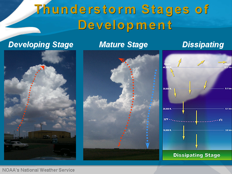
Towering cumulonimbus clouds signal the development of a thunderstorm.
Cloud Formations: Reading the Sky’s Mood
Clouds are like nature’s billboard for weather changes, and certain types scream “storm ahead.” Towering cumulus clouds, those puffy white ones that build upward like cotton candy stacks, are early builders of thunderstorms. As warm air rises, they grow taller, eventually turning into cumulonimbus clouds with anvil-shaped tops. These giants can reach 40,000 feet or more, creating the unstable conditions needed for lightning and heavy rain.
Shelf clouds, which look like a low, horizontal wedge under a storm, form when cool air from the storm pushes under warmer air, condensing moisture into a dramatic line. They’re a sure sign of strong winds and potential downbursts. Wall clouds, denser and lower-hanging, often rotate and can spawn tornadoes in severe cases. If you see clouds moving quickly or in opposing directions at different heights, that’s shear—a recipe for severe weather.
The logic here ties back to how storms form: warm, moist air rises rapidly, cools, and condenses into clouds. When these processes accelerate, visible cues like darkening bases or greenish tints (from hail or thick water droplets scattering light) warn of intensity. Boaters and hikers rely on these visuals because they’re immediate and don’t require gadgets.
Animal Behaviors: Wildlife’s Instinctive Forecasts
Animals sense storms long before we do, thanks to sharper senses for pressure, humidity, and even infrasound from distant thunder. Birds flying low to the ground is a classic sign; they do this because dropping pressure makes higher flight harder, or to avoid turbulence. In the Himalayas, large birds like griffons hug the terrain when storms approach, a behavior trekkers use to gauge safety.
Cows lying down in fields isn’t just a myth— they huddle to stay dry as humidity rises, preserving a patch of grass. Frogs croaking louder or more frequently signals moisture buildup, as they thrive in wet conditions and amp up calls before rain. Ants are pros at this too; they build taller mounds or scurry frantically to seal entrances when pressure drops, prepping for floods.
Insects ramp up activity right before a storm—flies and mosquitoes buzz more in humid air but vanish about an hour prior, avoiding the downpour. Spiders might abandon webs for sturdier spots if wind threatens. Even larger animals like bears or mules show agitation, seeking shelter or pacing restlessly. The reasoning? Evolution honed these responses for survival; animals detect minute changes we miss, like vibrations or scent shifts, making them reliable sentinels.

Animals often seek unusual shelter when sensing an approaching storm.
Plant and Environmental Cues: Ground-Level Warnings
Plants react to weather shifts in ways that are easy to spot if you know where to look. Leaves on trees like maples or poplars flipping to show their undersides happen when humidity surges, making petioles twist. This exposes the lighter side, creating a silvery sheen across a forest—a visual alert for imminent rain.
Pine cones are natural hygrometers; their scales close tight in high humidity to protect seeds, opening wide when dry. Pick one up—if it’s clamped shut on a clear day, moisture is building. Flowers closing petals, like daisies or tulips, shield pollen from rain, often hours before drops fall.
On the ground, watch for moisture levels. Damp soil or increased dew might seem counterintuitive, but sudden rises point to saturated air. In mountainous areas, orographic lifting—where air rises over terrain—can trigger storms faster, so valleys channeling wind amplify these cues. These plant responses make sense biologically: they minimize damage from wind or water, aligning perfectly with storm precursors.
Sky Colors and Optical Phenomena: Nature’s Light Show
The sky’s hue can forecast trouble. A red sky at morning warns of storms because sunlight scatters through a moist, dusty atmosphere ahead, letting red wavelengths dominate as bad weather approaches from the west. This old sailor’s rhyme holds in mid-latitudes where systems move west to east. At night, a red sky means the storm has passed.
Halos around the moon or sun form from ice crystals in high cirrus clouds, refracting light into a ring. A tight halo suggests distant rain, but a wide one means it’s close—often within 24 hours. Greenish skies during storms come from hail scattering blue light, leaving green tones, a sign of severe conditions.
These optical effects stem from atmospheric optics: particles and moisture bend light in predictable ways, giving us visual data on cloud height and composition.

A red sky at morning often signals approaching stormy weather.
Sensory Signs: Smells, Sounds, and Feels
Your senses can pick up storm clues too. Stronger earthy or ozone smells arise as humidity hydrates scent molecules, making them more volatile. That “rain smell” is geosmin from soil bacteria, released when pressure drops.
Sounds change as well—distant thunder rolls farther in humid air, but a sudden hush in the woods means animals have quieted, sensing danger. The “calm before the storm” is real: downdrafts suppress wind just before outburst.
Temperature drops sharply when cold fronts collide with warm air, fueling convection. If it cools fast on a hot day, watch out. These sensory shifts logically connect to physics—humidity alters sound waves, pressure influences scents, and fronts mix air masses.
Combining Signs for Better Prediction: Practical Tips
No single sign is foolproof, but clustering them boosts accuracy. For example, low-flying birds plus building clouds and gusty winds paint a clear picture. In the wild, note terrain: mountains accelerate storms via lifting, while open plains show wind shifts plainly.
For safety, count seconds between lightning and thunder—divide by five for miles away. If under 30 seconds, seek shelter. Blend these with modern forecasts for the best edge. Hikers in remote areas swear by these methods when tech fails.
Conclusion
Tuning into nature’s storm signals sharpens your awareness and could save the day. From cloud towers to ants on the march, these cues reveal the atmosphere’s inner workings. Next time you’re outside, scan the sky, watch the wildlife, and sniff the air—you might just outsmart the weather.